
Communities
CNI - Project Area
Project Area Maps
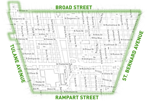
Choice Neighborhoods New Orleans covers the area roughly bounded by Rampart Street, Tulane Avenue, Broad Street and St. Bernard Avenue.
You may also view the Project Area relative to the following City of New Orleans geographic areas:
Project Area Data
The following table provides key population, housing, income, employment and crime data for the Iberville Housing Development and the surrounding Project Area. For comparative purposes, the same data elements are provided for Orleans Parish and the New Orleans Metropolitan Statistical Area (MSA).
| Iberville Housing Development | Project Area | Orleans Parish | New Orleans MSA | |
|---|---|---|---|---|
| Population1 | 1,238 | 12,241 | 343,829 | 1,167,764 |
| Population Change2 | -51.0% | -43.5% | -29.1% | -11.3% |
| Total Housing Units1 | 865 | 8,818 | 189,896 | 538,239 |
| Households / Occupied Housing Units1 | 482 | 5,428 | 142,158 | 455,146 |
| Vacant Units1 | 383 | 3,390 | 47,738 | 83,093 |
| Median Household Income3 | $9,571 | $22,917 | $36,258 | $47,188 |
| Population below Poverty Level3 | 55.3% | 40.7% | 23.3% | 15.9% |
| Employment (ages 16 and up)3 | 38.6% | 51.3% | 54.9% | 58.9% |
| Households without Access to a Vehicle3 | 63.3% | 40.0% | 20.0% | 9.7% |
| Workers Commuting by Public Transport3 | 25.6% | 22.8% | 8.2% | 2.9% |
| Workers Commuting by Foot/Bicycle3 | 3.0% | 12.4% | 6.5% | 3.0% |
| Murder Rate per 1,000 residents4 | 2.4 | 1.0 | 0.4 | n/a |
- U.S. Census Bureau - Decennial Census Count (2010)
- U.S. Census Bureau - Decennial Census Counts (2000 & 2010)
- U.S. Census Bureau - American Community Survey 5-year Estimates (2005-2009)
- Times-Picayune Crime Database (June 2010-May 2011)